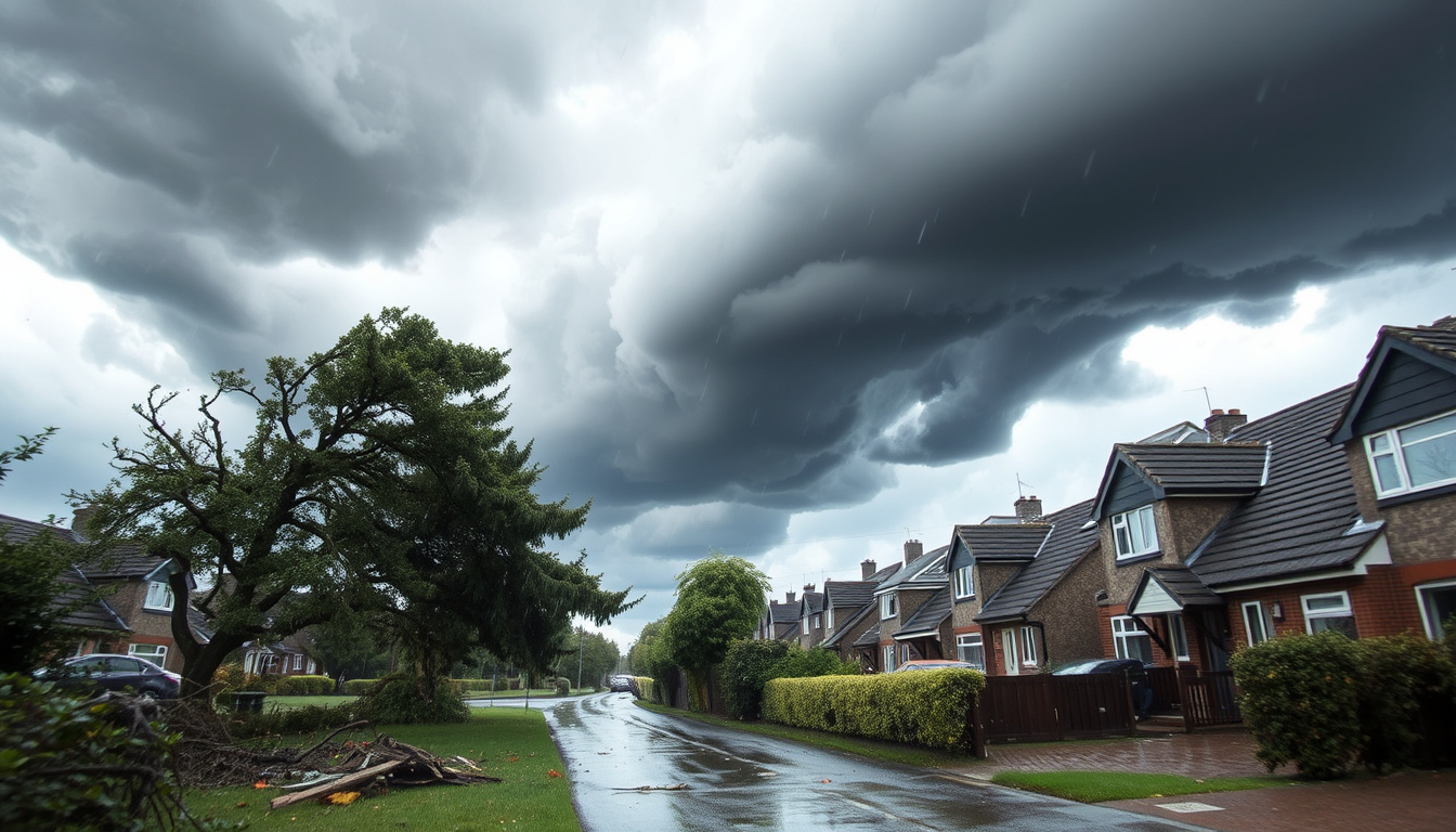

The Met Office has urged UK households to remain indoors as Storm Dave brings severe wind warnings across the country. Yellow alerts, with some amber warnings, cover large portions of Britain with gusts reaching up to 90 mph in exposed coastal and high-ground areas.
The storm, which arrived in early April 2026, has prompted authorities to warn of potentially dangerous conditions. Forecasters expect the strongest winds to impact roads, coastlines, and elevated terrain, creating risks for both property and personal safety. Officials are advising people in affected regions to avoid non-essential travel and take precautions if movement is unavoidable.
The advisory comes as Storm Dave moves eastward across the North Sea, bringing a dramatic shift from milder conditions to Arctic air. Chief meteorologist Jason Kelly noted that the transition to colder northwesterly winds would coincide with the most intense period of the storm, creating conditions that could rapidly deteriorate across many areas.
Why are UK households advised to stay indoors?
The Met Office issued its advisory due to the severe threat posed by gusts that could reach damaging speeds across densely populated regions. Flying debris, toppling trees, and structural damage represent the primary concerns for anyone caught outside during peak wind periods. The warning specifically targets unsecured outdoor objects that could become hazardous projectiles in these conditions.
Coastal communities face particular danger from the combination of high winds and spring tides, which could produce dangerous wave conditions along Irish Sea shorelines. High-ground locations, including the Scottish highlands and Pennine routes, risk not only strong winds but also accumulating snow that could create blizzard conditions, further endangering anyone travelling through these areas.
The Met Office has explicitly recommended that households in the most exposed areas remain indoors during peak gust periods. Those who must travel should exercise extreme caution and maintain awareness of rapidly changing conditions.
Understanding the Met Office Warning System
The yellow warning indicates that severe weather is possible and could affect plans, requiring people to consider how they might adjust their activities. Amber warnings signal a higher likelihood of disruption, with dangerous conditions expected that could pose a risk to life and property. The presence of both warning levels across different regions reflects the varied intensity of the approaching storm system.
According to the Met Office guidance on travelling in storms, rain and wind, individuals should monitor forecasts closely and avoid unnecessary journeys during the most severe periods.
Key insights from the advisory
- Met Office advisory specifically targets unsecured objects that could become flying debris
- Power outages remain possible in coastal and high-ground areas
- Avoidance of non-essential travel strongly recommended across all affected regions
- Conditions could deteriorate rapidly with little warning in some locations
- Blizzard conditions possible on Scottish hills due to heavy rain turning to snow
- Emergency services may face increased demand during the storm peak
| Fact | Details |
|---|---|
| Issued By | Met Office |
| Warning Type | Wind (Yellow/Amber) |
| Severity | High gusts, potentially damaging |
| Start Time | 5am Thursday, April 3 |
| End Time | Up to 7am Easter Sunday, April 5 (some areas) |
| Peak Period | Evening of April 4 |
What areas are affected by the strong winds?
Storm Dave’s impact varies significantly across different regions, with coastal and elevated areas experiencing the most intense conditions. The storm system swept in from the Atlantic, bringing strong westerly winds that were channelled and amplified by topography across the British Isles.
Scotland
Scotland faces the most severe conditions, particularly along coasts, high ground, and the northeast. Wind gusts of 60 to 90 mph have been recorded in these areas, with potentially severe gales creating dangerous conditions. Heavy rain transforming into snow across the highlands and elevated terrain raises the prospect of blizzard conditions on hills, creating additional hazards for anyone in these areas or attempting to travel through them.
Northern England, Midlands and Yorkshire
Areas including Wigan, Bolton, and broader regions across northern England, the Midlands, and Yorkshire experienced gusts ranging from 50 to 70 mph, with some local spots seeing speeds up to 80 mph. The Met Office warnings covered these densely populated areas where the combination of urban infrastructure and strong winds could lead to fallen branches, damaged property, and travel disruption. Urban environments present their own challenges, with tall buildings creating wind tunnels and loose fittings potentially becoming hazardous.
Wales and Irish Sea Coasts
Welsh communities and those along the Irish Sea coasts braced for gusts of 60 to 70 mph as strong winds transferred from the west. Coastal defences and seafront properties face particular exposure, with the combination of high tides and storm surge potentially creating flooding risks alongside the wind danger.
Northern Ireland
Southwesterly gusts of 40 to 60 mph affected Northern Ireland, accompanied by heavy rain that began easing by midday in some areas. The shorter duration of the most intense conditions in this region provided some relief, though conditions remained challenging throughout the morning of April 4.
Coastal and high-ground locations faced the highest speeds, reaching up to 70-90 mph in the most exposed areas. Inland regions widely experienced 50-55 mph gusts, with the severity diminishing somewhat away from the coasts and hills.
How long will the strong winds last?
The duration of the warning period spans several days, though the intensity varies significantly between different phases of the storm’s passage. Understanding this timeline helps households plan their activities and determine when outdoor exposure becomes less hazardous.
Warning Timeline
Yellow wind warnings commenced at 5am on Thursday, April 3, extending across Scotland, northern England, the Midlands, Wales, and Yorkshire until 8pm that evening. Some warnings extended through to 7am on Easter Sunday, April 5, reflecting the prolonged nature of the disturbance as it moved slowly across the country.
Additional yellow warnings for rain and snow came into effect during the afternoon of April 4 and continued into the evening, with amber wind warnings noted for the evening gusts as conditions peaked. Northern Ireland’s warning period ran from the morning of April 4 until approximately 12pm, a shorter window than mainland areas due to the storm’s trajectory.
Peak Intensity Period
Winds reached their maximum intensity during the evening of April 4, with the storm system then shifting eastward across the North Sea overnight. Eastern coasts continued to experience gusty conditions even as the main body of the storm moved away, though conditions improved significantly inland and to the west as the disturbance departed.
The transition to colder northwesterly winds on Friday, April 4, marked the arrival of more seasonal temperatures following the storm’s passage. While this brought brighter conditions to northern areas, showers and lingering gales persisted in some coastal regions, maintaining elevated risk levels even as the immediate threat diminished.
- 5am Thursday, April 3: Yellow wind warnings commence across Scotland, north England, Midlands, Wales, Yorkshire
- Afternoon, April 4: Additional yellow warnings for rain and snow issued; amber wind warnings noted for evening
- Evening, April 4: Peak gusts reported as storm reaches maximum intensity
- Overnight, April 4-5: Storm shifts to North Sea; winds ease significantly but remain gusty on eastern coasts
- 7am Sunday, April 5: Extended warnings expire in some areas; conditions gradually improve
What safety precautions should people take?
The Met Office has published detailed guidance for households facing severe wind conditions, emphasising that preparation and sensible choices can significantly reduce the risk of harm. These precautions apply particularly to those in the most affected areas but serve as useful guidance wherever strong winds occur. For those in exposed areas, staying indoors represents the single most effective measure to avoid injury from severe gales and flying debris, and you can find more safety tips at Best advent calendars 2025.
For those in exposed areas, staying indoors represents the single most effective measure to avoid injury from severe gales and flying debris. If outdoor exposure is unavoidable, maintaining awareness of surroundings and identifying shelter locations becomes essential.
Driving in Strong Winds
Road users face particular challenges during high-wind events, with the Met Office offering specific advice for drivers. Using dipped headlights in low visibility conditions improves both the driver’s vision and their visibility to other road users. Gripping the steering wheel firmly with both hands provides crucial control, particularly when overtaking other vehicles or traversing exposed sections of road.
Side winds pose a particular hazard near trees, buildings, bridges, and other structures where wind patterns become unpredictable. Drivers should reduce speed in these areas and maintain firm control of their vehicles. Extra space should be allowed for cyclists, motorcyclists, and pedestrians who may be blown off their intended course by sudden gusts, as these road users have less stability and are more vulnerable to wind effects.
Property and Outdoor Items
Secure storage or weighting of outdoor furniture, trampolines, bins, and other loose items prevents these objects from becoming dangerous projectiles. Garden structures, fencing, and temporary installations should be checked and reinforced where possible. These precautions protect not only the householders themselves but also neighbours and passersby from potential harm.
Monitoring and Preparation
Regular monitoring of Met Office forecasts allows households to track changing conditions and adjust their plans accordingly. Having emergency supplies ready, including torches, batteries, phone chargers, and essential medications, provides resilience against potential power cuts. Neighbours and family members, particularly those living alone or with mobility limitations, should be checked on where possible.
For those seeking to understand broader weather patterns, the Spain Portugal Weather Heatwave – Peak Temps, Duration and Safety Tips article provides context on how extreme weather events are becoming more frequent across Europe.
What do we know with certainty about this event?
| Confirmed Information | Information That Remains Unclear |
|---|---|
| Met Office advisory is active across multiple regions | Precise numbers of properties experiencing power outages |
| Gusts exceeding 60 mph recorded in exposed areas | Full extent of minor structural damage across affected regions |
| Warning periods confirmed for each region | Specific locations of fallen trees or blocked roads |
| Peak wind timing identified as evening of April 4 | School closures or travel restrictions in individual areas |
| Storm Dave named and tracked by Met Office | Insurance claims volume and damage assessments |
What is the broader context of this storm?
Storm Dave represents the latest in a series of named storms to affect the United Kingdom during the 2025-2026 winter and spring seasons. The Met Office naming system, developed in partnership with equivalent agencies in Ireland and the Netherlands, aims to improve public awareness of severe weather events and encourage appropriate preparation.
The timing of the storm, arriving in early April, marks a notable transition from the relatively mild conditions that had characterised March. The shift to northwesterly winds brought cold air masses from polar regions, explaining the snow potential alongside the strong winds. This combination of wind and precipitation created conditions conducive to blizzard formation on higher ground, particularly in Scotland where significant snowfall accumulated on hills already saturated by preceding rainfall.
The risk of disruptive, damaging winds affecting roads, coasts, and high ground reflects the exposure of British infrastructure to Atlantic weather systems. Irish Sea and northern coasts faced particular gale conditions, while the potential for blizzard conditions in northwest Scotland added an additional dimension to the meteorological briefing. The Met Office continues to monitor conditions and update forecasts as the situation develops.
For those tracking current events alongside this weather emergency, the Breaking News UK Express – Starmer Faces Mounting Crises article provides additional context on the broader news landscape during this period.
Sources and Official Guidance
“Stay indoors if winds pick up” — Met Office advisory
“An active weather front brought heavy rain turning to snow over the Scottish highlands, with winds from an active weather front; colder nationwide by Friday with showers and gales; brighter but showery further north.” — Met Office forecast context
The Met Office maintains real-time warning information on their website, which residents are encouraged to consult for the latest updates. Travellers should also review official guidance on travelling in storms before undertaking any journey through affected areas.
Summary
Storm Dave has prompted the Met Office to advise UK households across multiple regions to remain indoors where possible as severe wind warnings take effect. Gusts reaching 90 mph in exposed coastal and high-ground areas, combined with heavy rain turning to snow in Scotland, create hazardous conditions that warrant careful attention to official guidance. The warning period spans from April 3-5, 2026, with peak intensity expected during the evening of April 4. Motorists are advised to exercise extreme caution, grip steering wheels firmly, use dipped headlights in poor visibility, and allow additional space for vulnerable road users. Continued monitoring of forecasts and adherence to safety advice will help households navigate this period of severe weather safely.
Frequently Asked Questions
What disruptions are caused by the winds?
The strong winds risk disrupting roads, coasts, and high ground with potentially damaging gusts. Gale-force conditions along Irish Sea and northern coasts could affect travel and coastal communities. Power outages remain possible in exposed areas.
Are schools or travel affected?
Individual schools and local authorities make their own decisions regarding closures based on local conditions. The general advisory is to avoid non-essential travel during peak wind periods, particularly on exposed routes and coastal roads.
What is the weather forecast after the winds?
Following the storm’s passage, conditions are expected to turn colder nationwide with brighter but showery weather in northern areas. Eastern coasts may remain gusty even as the main storm system moves into the North Sea.
Is there a Met Office warning for strong winds?
Yes, the Met Office has issued multiple yellow wind warnings across the UK, with some amber warnings for evening gusts on April 4. These warnings cover Scotland, northern England, the Midlands, Wales, Yorkshire, and Northern Ireland.
How strong are the expected winds?
Gusts of 60-90 mph have been recorded in exposed coastal and high-ground areas. Inland regions widely experienced 50-55 mph, with locally higher speeds of up to 80 mph in some spots.
When will the strong winds end?
Winds are expected to ease overnight on April 4-5 as the storm moves into the North Sea. However, some gusty conditions may persist on eastern coasts, with the most extended warnings expiring by 7am on Easter Sunday.
Related stories


Thomas Grant covers Westminster, councils, policy and government affairs across the UK.